

Hiking, running, biking – whatever your activity of choice, Estonia’s nature trails will take you through national parks, forests, bogs and along the sea. Breathe some of the purest air in the world and follow in the tracks of fox, rabbits and moose. The following trails range from easy to advanced, some even accessible for wheelchair users.
Viru Bog Trail, Kuusalu
| Location | Kuusalu Municipality, Harju County Object no.19 on the national park map |
| Driving directions | Drive 52 km on Tallinn–Narva road (Road no. E20), turn left (sign “Võsu 22, Loksa 15”). Drive 1 km to the parking area to the right of the road (sign “Viru raba”). The trail starts from the parking area. |
| Geographic coordinates | Long-Lat WGS 84 latitude: 59.464375 longitude: 25.638328 |
| L-EST 97 x: 6592980.2 y: 592885.9 |
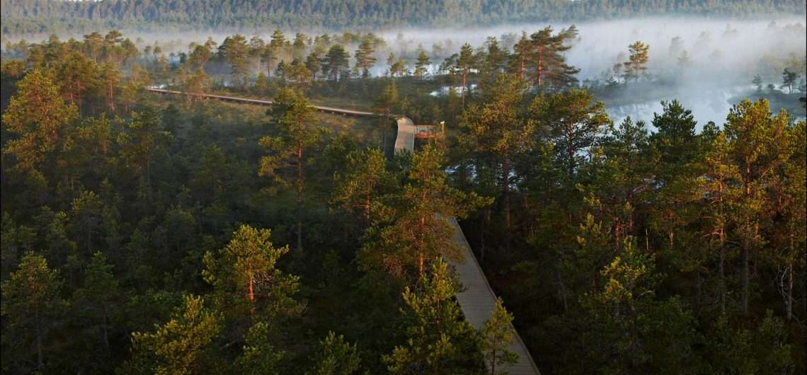
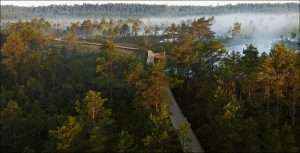
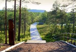
3,5 km is one way, circle will be 6 km. The trail introduces the vegetation and terrain characteristic of the raised bog in Estonia.
To protect the vegetation and soil we ask hikers to keep on the boardwalk. Cycling on the boardwalk is not allowed!
Abula hiking trail
| Location | Saaremaa municipality in Kalasma and Abula villages Object no 40 on recreation area map |
| Driving directions | Starting from Kuressaare: Drive 30 km on the Kuressaare-Kihelkonna road, from the crossroads turn tu Pidula. Drive 9 km and from the crossroads turn left. Drive 1 km and turn right. Drive 3 km. Abula hiking trail is located at Mustjala–Kalasma village road, 8.4 km from Mustjala. The trail starts at the Kalasma campfire site. |
| Geographic coordinates | Long-Lat WGS 84 latitude: 58.474276 longitude: 22.115466 |
| L-EST 97 x: 6483103 y: 390061 |
Karula long hiking trail (36 km)
| Location | In Karula National Park. The trail has no definite starting or end point. Object no 24 on the national park map. |
| Driving directions | Drive 8 km from Antsla towards Haabsaare, turn right 50 m after the Haabsaare bus stop (signs “Karula rahvuspargi külastuskeskus 7 km”, “Saru 20 km”). Drive 7 km on Haabsaare–Saru road and follow the signs pointing to the Karula National Park’s visitor centre, which lead you to the trail. |
| Geographic coordinates | Long-Lat WGS 84 latitude: 57.7124683 longitude: 26.5051262 |
| L-EST 97 x: 6399498 y: 649297 |
Meenikunno hiking trail (5.8 km)
| Location | Räpina municipality, Põlva County. Object no 25 on the recreation area map. |
| Driving directions | Drive 15 km from Räpina towards Võru, turn left towards Värska. Drive 3.8 km and turn right towards Meenikunno Landscape Protection Area. Drive another 5.5 km and turn right. Drive about 1.5 km to the parking area, where the sign “Liipsaare” points to the right. The start of the hiking trail is about 500 m away. |
| Geographic coordinates | Long-Lat WGS 84 latitude: 57.932105 longitude: 27.310046 |
| L-EST 97 x: 6426011 y: 696026 |
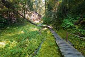
The 5.8 km circular hiking trail runs on 2.4 km boardwalk and 3.4 km forest path. There are 13 information points introducing the bog and forest along the trail. There is an observation tower on the Liipsaare end of the hiking trail. It is a fascinating trail for nature enthusiasts—hikers, berry-pickers, bird-watchers, etc.
Rõuge primeval valley hiking trail (10 km)
| Location | Rõuge municipality, Võru County. Object no 14 on the nature park map. |
| Driving directions | Drive along Võru–Valga road (Road no. 67) and turn towards Rõuge. Before Rõuge turn left (follow the sign “Rõuge Suurjärve külalistemaja 1,5 km”) and drive to the junction, with a red brick building (schoolhouse) across the road and the Rõuge school bus stop on your right. Turn left at the junction and after the schoolhouse immediately to the right (follow the signs “Ööbikuorg 0,6 km”, “Plaani 11 km”, “Haanja 8 km”). The bordermark of Haanja Nature Park and cemetery are on the left. Drive on (there is a lighted cycle and pedestrian track at the side of the road), and where the cycle and pedestrian track ends, you’ll see Rõuge Ööbikuorg visitor centre and parking area on the right. Near the visitor centre there are signs and information boards introducing the surrounding area. |
| Geographic coordinates | Long-Lat WGS 84 latitude: 57.72783 longitude: 26.93450 |
| L-EST 97 x: 6402243.7 y: 674799.9 |
The 10 km hiking trail descends from near the village swing to Rõuge primeval valley, goes past a small pond and runs along the slope of the valley, which is rich in springs. There are two hydraulic rams operating on the shore of Lake Liinjärv. Hydraulic ram is a “perpetual-motion” pump using hydraulic power and is capable of pumping water as high as ten metres or more. The trail continues along the village road between the Liinjärv and Valgjärv lakes and offers wonderful views towards Ööbikuorg valley and Linnamägi. Then the trail goes along the south-western shore of Lake Rõuge Suurjärv – the deepest lake in Estonia. Next the trail goes along the chain of lakes (Ratasjärv, Tõugjärv, Lake Kahrila) to the Hinni canyon.
Salevere hiking trail (1.5 km)
| Location | Salevere village, Lääneranna municipality, Pärnu County Object no 1 on the national park map |
| Driving directions | Drive 56 km on Risti–Virtsu road (Road no. 10) to Ridase, turn left towards Salevere. Drive 9 km on gravel road to Salevere village, pass the two-storey residential houses and arrive at the parking area and recreation site, which also mark the start of the hiking trail. |
| Geographic coordinates | Long-Lat WGS 84 latitude: 58.690320 longitude: 23.580652 |
| L-EST 97 x: 6505698 y: 475684 |
Comments